Document details

Abstract
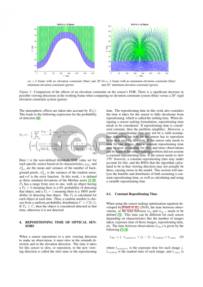
As the number of Resident Space Objects around Earth continues to increase, the need for an optimal sensor tasking strategy, specifically with Ground-Based Optical sensors, continues to be of great importance. Several commercial and government agencies already have or are building large sensor networks to track the increasing resident space object population. With these large sensor networks, it is integral to coordinate the sensing efforts of the constituent sensors in an optimized way. One aim of these sensor networks is to give complete coverage of a given orbital regime. A regime of interest, e.g., is the Geosynchronous region. Complete coverage constellations have been proposed based on geometric considerations, such as the multi-sensor system developed by Ackermann et al. (2018). The multi-sensor system was developed to observe all geosynchronous Earth-orbiting objects within a single night, based on general geometric considerations but including averaged night sky brightness and local weather conditions. In this paper, the given complete sensor geometric configuration is combined with an actual real-time sensor tasking optimization, instead of focusing on broad averaged theoretical limits, which is evaluating exact nightly coverage. The objects that are used are Geosynchronous Earth-orbiting objects taken from the United States Strategic Command’s Two Line Element catalog for the night of March 19th, 2019. In this paper, the optimization of the entire 34 sensor network is shown and it is evaluated if complete coverage is reached. From the analysis, the developed system does not reach complete coverage of the entire geosynchronous region, when the catalog has realistic orbital uncertainties. Coverage is only reached when exact orbital knowledge is assumed and the probability of detection is assumed to be one for all objects at all times. The paper goes into the details of several optimization decisions that are relevant when using the optimization in an actual sensor network. The two aspects that are focused on in this paper. First, heuristic local horizon constraints versus using an actual estimate of the probability of detection are studied. The attenuation effects change the probability of detecting the object of interest. To avoid these attenuation effects, sensor operators generally employ heuristic rigid elevation constraints. These constraints can limit the performance of the sensor in observing geosynchronous objects by limiting the sensor’s field of regard. Secondly, this paper studies the use of the actual, experimentally determined sensor repositioning time, which is more optimal but also more computationally demanding, versus a fixed, but sub-optimal repositioning time. To save computational time when simulating and developing a sensor tasking strategy, often a constant repositioning time is assumed for the ground-based sensors. This allows for fast computation times but does not represent the real-world system. The results of the research of the paper show that a probability of detection use is superior to heuristic elevation constraints. If a heuristic elevation constraint needs to be applied, 25 to 35 degrees is recommended in the absence of physical obstacles at the sensor site and from an atmospheric attenuation point of view. Several trade-off scenarios regarding re-positioning times are shown and compared.
Preview
