Document details
8
1
T. Flohrer, S. Lemmens, F. Schmitz

Abstract
We are developing a passive optical system for the detection of space debris and the determination of their orbits to allow subsequent laser ranging to uncatalogued objects. The hardware is a sensitive camera which records pictures every few seconds of a fixed segment of the sky. We report on recent progress of the development of a streak detection software which processes the images and measures the angular position of satellites and debris parts. The software is designed to work under challenging circumstances which include partly cloudy or lens flare.
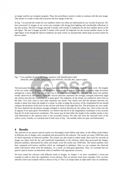
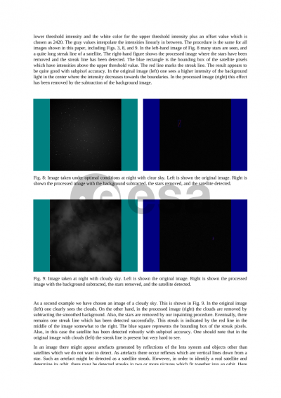
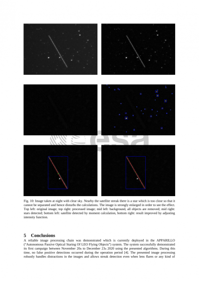
First, the background light is considered. The raw image initially has a broad and irregular histogram, but by subtracting a filtered and blurred image we shift the local average intensities to a global mean value. In this way, we obtain a histogram with a very sharp Gaussian like peak which represents the background light. Next, we determine a high-intensity boundary of the intensity peak which serves as a threshold value to separate the objects (e.g. stars or streaks) from the background. We determine the pixel coordinates of the stars (points) and of the satellites and debris parts (streaks).
Second, we perform astrometry in order to transform the pixel coordinates into RA/Dec coordinates of the equatorial coordinate system of the sky. For this purpose, the software package of the project http://astrometry.net is applied. The stars are used to determine the parameters of the transformation and some parameters of the optical system, including the distortion coefficients. After this, we calculate the RA/Dec coordinates of the streaks. Up to this stage all calculations are done separately for each image while the images come successively one after the other from the hardware.
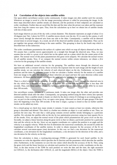
In a third step the streaks of satellites and debris objects observed in several different images are combined into traces in the sky which represent the orbits of space objects. Streaks are correlated by the angular velocity and direction. Finally, we fit a straight trace line with constant velocity into the observed data. This way we obtain a circular fit of the satellites and the debris trajectory. Eventually, for each found orbit the results are written into a “tracking data message” (TDM) which allows data sharing with other stations or databases.
We present the software design which is used with the staring hardware developed by the Institute of Technical Physics of the German Aerospace Center (DLR).
Further developments are needed, which include initial orbit determination and subsequent active laser tracking in order to observe the objects and measure the distance precisely using active laser ranging. This will allow the orbit parameters of uncatalogued objects to be determined with a high degree of accuracy.
Preview