Document details
8
1
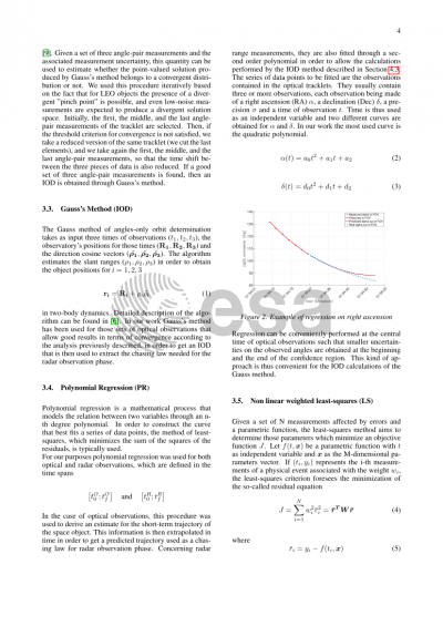
T. Flohrer, S. Lemmens, F. Schmitz

Abstract
The exploitation of space over the last fifty years has led to an increase in the population of debris in orbit around the Earth. This large amount of space objects (SOs) can generate damage to satellites and lead to the loss of the mission. It is thus fundamental to catalogue each SO to enable safety operations.
One of the crucial phases of the cataloguing process is the identification of newly detected objects and their initial orbit determination (IOD). In particular, the environment of low Earth orbits (LEO) is critical due to the large number of both operating satellites and unknown space debris. In this region, space surveillance is generally handled by radars which typically do not provide accurate angular measurements. As a result, the uncertainty of the IOD solution of newly detected objects is potentially large and this reduces the possibility of re-observing them.
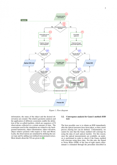
To mitigate this risk, we propose an analysis of the combined use of radar and optical instruments in a stare and chase strategy as follows. Through a large field of view staring optical camera, the prediction of new SOs’ trajectory is obtained. This is then sent to a radar instrument which performs the chasing phase. The radar pointing law is obtained either through a quadratic regression of the optical observations or through the propagation of an optical IOD solution, depending on the quality of the optical measurements. If this pointing law is accurate enough, the range and range rate measurements are recorded, and a Least Squares is performed over both observed tracks to refine the orbit. This approach aims to merge the precise optical angular measures with the precise radar range measurements to achieve better IOD solutions. In addition, the combination of the low-cost and more practical optical cameras with existing radar observatories results in an expanded observation network which can produce an increase in the number of detected objects.
In such a system the radars may not be in good locations for optical observation which consequently can result in degradation of the overall performance. To overcome this problem, two different architectures are analysed: a co-located strategy, in which the two instruments are at a same geographical location, and a separated strategy, in which the optical instrument is placed in a more favourable location. In this study, four observation locations in France were considered. The simulated observation campaign used a statistically sampled population of LEO SOs to optimally point the optical camera, for each place at any time of the year, in order to maximise the number of detected objects and the accuracy of the determined orbits. This optimization criterion gave therefore a preference to the pointing providing a higher amount of SOs recaptured by the radar. All these considerations resulted in low elevations and near-polar azimuths pointing in accordance with the main features of LEO SOs’ orbits. Lastly, another remarkable result is that quadratic regression of angle measurements allowed for radar recaptures in case of Gauss’ IOD failures, thus increasing the number of high-quality orbits.
Preview