Document details
8
1
T. Flohrer, S. Lemmens, F. Schmitz

Abstract
The ability to study the performance of different sensor configurations is crucial for the development of any sensor network that provides data for Space Surveillance and Tracking (SST) services. Any software suite devoted to this purpose shall be able to assess the performance of an existing network in terms of effectiveness and robustness, as well as to estimate the advantages and disadvantages of any structural change, such as the addition of new sensors or the upgrade of existing ones.
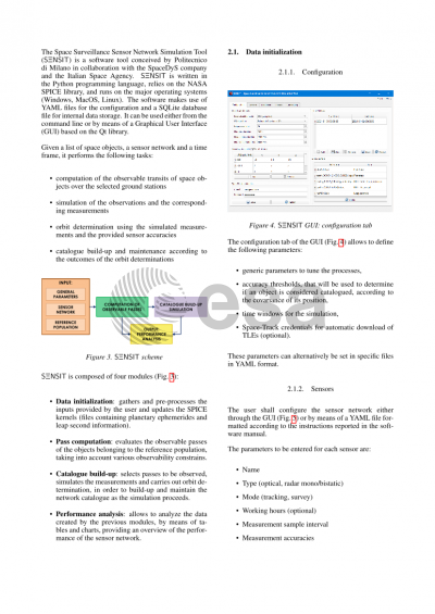
This paper is devoted to introducing the Space Surveillance Sensor Network SImulation Tool (S3NSIT) and its contribution to the above task. S3NSIT is a software suite developed for the Italian Space Agency, which has been conceived to perform a statistical analysis of the observational and cataloguing capabilities of a sensor network. The software can model optical, radar and laser ranging sensors and simulate different operational scenarios. The user is provided with the necessary interfaces to define the list of sensors composing the network, along with a reference population of space objects in terms of Two-Line Elements or orbital parameters. The typical sensor properties that can be specified by the user include type, operating mode (survey or tracking), location, measurement accuracy, pointing constraints, sensitivity and time availability. The provided sensor properties and object population are processed to predict the transits that can be successfully detected by each sensor, considering visibility and detectability constraints. The passages are analyzed to assess the network capabilities in terms of number of observations and catalogue coverage. Dedicated plots are provided to compare sensors in terms of coverage, to identify overlapping in the sets of observed objects, and to provide an estimate of the level of complementarity or redundancy.
Afterwards, the software simulates the measurements gathered by the network during the passages and processes them to carry out initial orbit determination and orbit determination refinement, with the aim of assessing the network performance in terms of catalogue build-up and maintenance. All the results are exposed to the user in informative tables and graphs with different levels of detail, starting from a general overview of the network performance up to the complete list of the passages observed by each sensor. The user can also browse the object catalogue of the network, analyzing its evolution in time.
The modularity of the software allows the user to easily modify the properties of the network and to carry out a sensitivity analysis to different parameters, such as the number and location of the sensors or their characteristics. This is expected to ease the setup process of sensor networks for SST, as well as the identification of the most promising upgrades to be recommended. As a side-product, the tool grants the opportunity to show and export all the data associated to the observable passages, including their pointing requirements, allowing for further analyses. The paper presents in detail the software architecture and its functionalities, and shows the results provided in typical use cases.
Preview