Document details
9
1
S. Lemmens, T. Flohrer, F. Schmitz

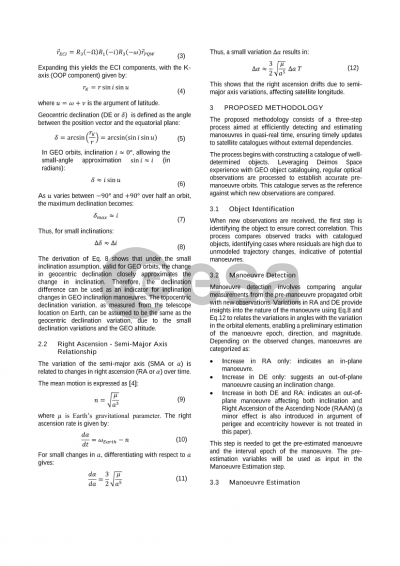
Abstract
The maintenance of a comprehensive catalogue of space objects has lately become critical, due to the growing number of objects which demands augmented cataloguers’ resources and increases the necessity of ground sensors’ observations. Furthermore, unexpected changes in trajectories introduced by satellites equipped with propulsion means jeopardizes the cataloguing accuracy, so an ad-hoc strategy needs to be assessed when treating operational satellites performing manoeuvres.
When processing a post-manoeuvre track, three situations may arise. If the cataloguer manages to correlate the track to the correct object, the orbit determination (OD) generates high residuals (i.e. differences between observed and computed measurements), therefore reducing the computed orbit accuracy. On the other hand, if the track does not correlate to the catalogued object, it will be considered belonging to an unknown object, thus not associated to any NORAD ID. Lastly, post-manoeuvre measurements can be also confused with measurements of other objects, producing miscorrelations and even worsening their orbit estimation. Manoeuvres are not usually known a-priori, and this fact creates the need to detect, estimate and store manoeuvres data.
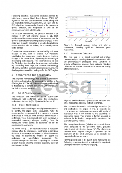
This study aims to tackle these challenges focusing on manoeuvrable satellites in GEO region, hence taking advantage of Deimos experience with the cataloguing of such objects and as optical data provider. Based on a catalogue of well-determined objects, constructed by processing regular optical observations, the proposed methodology is a three-step process. The first one consists on the identification of the object whose observations are being processed. Afterwards, the detection of a possible manoeuvre is carried out by comparing the angles belonging to the pre-manoeuvre propagated orbit with the observed measurements. The variation of the angular differences helps identify the nature of the manoeuvre and a first guess of its epoch, direction, and magnitude can be therefore estimated. Finally, a proper manoeuvre estimation is performed: with the initial orbit, post-manoeuvre tracks and the pre-estimated manoeuvre data in input, it becomes possible to determine the manoeuvre using a Batch Least Square OD algorithm. The strength of this methodology lies on its ability to detect and estimate manoeuvres in quasi-real time without relying on or waiting for external catalogues. In addition to this methodology, new techniques reducing the miscorrelations are presented, like data analysis for manoeuvre patterns recognition and forecasting, and study of light curves behaviour to predict upcoming manoeuvres.
The proposed approach offers a robust solution to the challenges posed by the cataloguing of manoeuvring objects in the GEO region. By leveraging optical sensor data and advanced orbit determination techniques, it enables the detection, estimation, and cataloguing of manoeuvres in quasi-real time, addressing the uncertainties associated with satellite trajectory changes due to manoeuvres. This methodology thus contributes to mitigating risks in increasingly congested orbits, ensuring the safety of operational satellites, and promoting the long-term sustainability of space activities.
Preview