Document details

Abstract
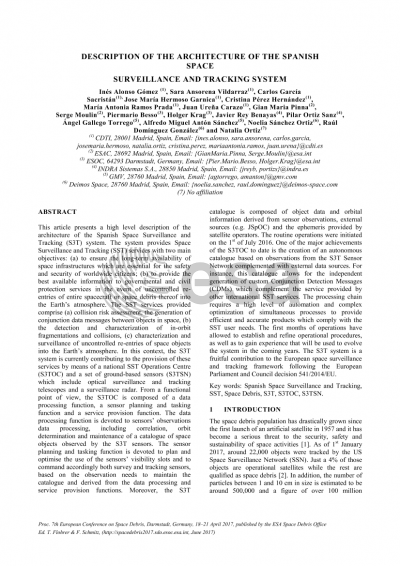
This article presents a high level description of the architecture of the Spanish Space Surveillance and Tracking (S3T) system. The system aims at providing space surveillance and tracking (SST) services for institutional users and satellite operators in order to ensure the long-term availability of space infrastructures which are essential for the safety and security of worldwide citizens. The SST services provided comprise the collision risk assessment, the generation of conjunction data messages between objects in space, the detection and characterization of in-orbit fragmentations and collisions and the prediction, characterization and surveillance of uncontrolled re-entries of space objects into the Earth´s atmosphere. In this context, the S3T system is currently contributing to the provision of these services by means of a national SST operations centre (S3TOC) and a set of ground-based sensors which include optical surveillance and tracking telescopes, a satellite laser ranging station and a radar. From a functional point of view, the S3TOC is composed of a data processing function, a sensor planning and tasking function and a service provision function. The data processing function is devoted to sensor observations data processing, including correlation, orbit determination and maintenance of a catalogue of space objects observed by the S3T sensors. The sensor planning and tasking function is devoted to the planning and tasking of both survey and tracking sensors based on the observation needs derived from the data processing and service provision functions. Moreover, the S3T catalogue is composed of object data and orbital information derived from sensor observations and external sources (e.g. JSpOC, satellite ephemeris provided by satellite operators). Finally, the service provision function is devoted to the provision of SST services including collision warning, re-entry warning and fragmentation detection. Furthermore, the S3TOC comprises two different environments; referred to as non-secure and secure operational environments prepared to manage unclassified and classified information depending on the operational needs. The nominal operations were initiated on the 1st of July 2016. One of the major achievements of the S3TOC to date is the creation of an autonomous catalogue based on observations from the S3T sensor network complemented with external data sources. For instance, this catalogue allows for the generation of custom conjunction detection messages (CDMs) which complement the service provided by other international SST services. The processing chain requires a high level of automation and complex optimization of simultaneous processes to provide efficient and accurate products which comply with the SST user needs. The first months of operations allowed to establish operational procedures and to learn how to operate the system, experience which will be used to evolve the system in the coming years. All in all, the S3T system is foreseen to be a fruitful contribution to the European space surveillance and tracking framework following the European Parliament and Council decision 541/2014/EU.
Preview
