Document details
6
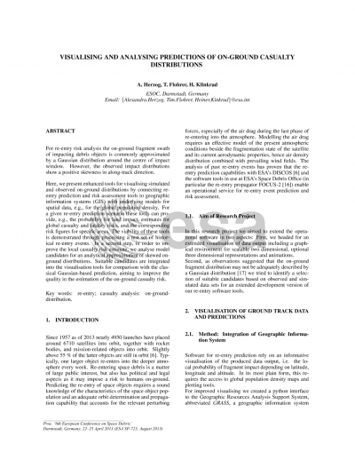
1
L. Ouwehand

Abstract
For re-entry risk analysis the on-ground fragment swath of impacting debris objects is commonly approximated by a Gaussian distribution around the centre of impact window. However, the observed impact distributions show a positive skewness in along-track direction. Here, we present enhanced tools for visualising simulated and observed on-ground distributions by connecting reentry prediction and risk assessment tools to geographic information systems (GIS) with underlying models for spatial data, e.g., for the global population density. For a given re-entry prediction scenario these tools can provide, e.g., the probability for land impact, estimates for global casualty and fatality risks, and the corresponding risk figures for specific areas. The viability of these tools is demonstrated through processing a test set of historical re-entry events. In a second step, in order to improve the local casualty risk estimate, we analyse model candidates for an analytical approximation of skewed on-ground distributions. Suitable candidates are integrated into the visualisation tools for comparison with the classical Gaussian-based prediction, aiming to improve the quality in the estimation of the on-ground casualty risk.
Preview