Document details
2
1
T. Flohrer, R. Moissl, F. Schmitz

Abstract
The number of man-made objects sent to space has risen in the last decades, leading to an overcrowded environment of resident space objects and orbital debris. Consequently, the space cataloging activities are becoming increasingly challenging year after year.
Passive Ranging (PR) is proposed as a lower-cost alternative to the existing tracking techniques such as radar or optical observations, capable of providing improved latency, timeliness (24/7 access to data without climate conditions or sunlight dependency) and accuracy. It allows for a rapid detection and estimation of maneuvers in the order of few hours, both for electrical and chemical satellites, and it can be integrated into SST-dedicated operation centers. This technology is completely autonomous and automated, and keeps a significantly lower cost for deployment, operations and maintenance than the other typical SST systems.
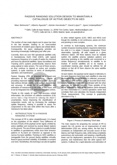
The concept of passive ranging is rather straightforward. It is based on the acquisition of the relative Time Difference of Arrival (TDoA) of the payload carrier signal, emitted by active satellites and received by several distant stations on the ground. The use of these systems is usually limited to satellites in geostationary orbit since their emission patterns in Ku-band are extensive as opposed to the narrow Ka-band satellites. Pointing to GEO satellites is manageable from the ground (being satellites virtually fixed in space) and their visibility (if available) is constant over time. Nonetheless, this technique can also be applied to other orbital regimes (LEO, MEO and HEO) even though the visibility is not continuous, passes are short, and pointing is more complex.
In this paper, an overview of the development of a passive ranging system is provided along with a feasibility and performance study (in terms of orbit determination) including a budget error. Then, an end-to-end software prototype for a passive ranging system is presented. It allows to entirely simulate a passive ranging network for a set of user-defined GEO active satellites and to process real TDoA data as well. In both cases, the orbital information for the tracked satellites is maintained based on the processing of the TDoA data, including the detection and estimation of maneuvers.
Finally, the impact that the inclusion of such a system into an SST-dedicated operations center is assessed. Thanks to the supply of rapid high-accuracy orbital information, the provision of collision-avoidance (CA) service takes a leap forward by reducing the object’s uncertainties, hence improving the classification of conjunction events, and by increasing the catalogue update frequency, making it possible to assess the conjunctions in the new orbit within few hours after a maneuver has taken place.
All these improvements give as a result a more agile and reliable CA service which is of vital importance considering the staggering increase in man-made objects and debris that populate the most demanded orbits such as the GEO regime.
Preview