Document details
9
1
S. Lemmens, T. Flohrer, F. Schmitz

Abstract
With the current rapid growth in the space object population, accurate orbit determination for the purposes of Space Traffic Management and safe and efficient spacecraft operations is becoming ever more critical. The range of commercially available ground based sensor data is diverse and fragmented, and any commercial Space Traffic Management service would likely have to work with data from various sources and sensor types. In this context this paper presents a description of the Multi Source Data Correlator project conducted by Neuraspace in conjunction with ESA’s Space Debris Office. This project was conducted under the GSTP program.
The objective of the project was to produce a prototype service that could ingest data from various ground based sensors and perform accurate orbit determination, with a view to integration in a commercial space traffic management service.
The paper breaks down into three sections; an outline of the tracking data obtained for the project, a description of the software architecture and design choices, and a summary of the results obtained. Additionally a discussion of future developments that will build on the work done under this project is provided.
Since Neuraspace’s own optical telescopes were not available at the time, optical telescope data was provided by Deimos, using similar sensors to the ones Neuraspace now has installed in Portugal and Chile. A tracking campaign was conducted during the summer of 2023 on a number of LEO objects. Digos facilitated the provision of laser ranging data for debris objects. Laser data is also available via ILRS for various calibration targets and was included in the testing dataset.
Due to the limited commercial availability of radar data, an experiment was conducted in cooperation with EISCAT using the UHF radar in Tromsø. The radar was used over a period of 5 days with a 2 hour tracking period each day. The targets were ILRS calibration objects enabling the accuracy of the resulting orbit determination to be established. The experiment was successful in tracking and performing orbit determination on the objects. Remaining issues and constraints are discussed. Neuraspace looks forward to working with EISCAT again in the future, especially when the next generation radar systems are operational. These will allow a much greater degree of operational agility than the existing system, making it much better suited to SSA applications.
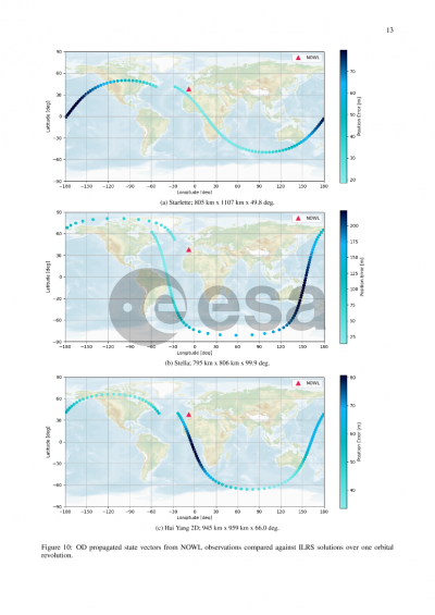
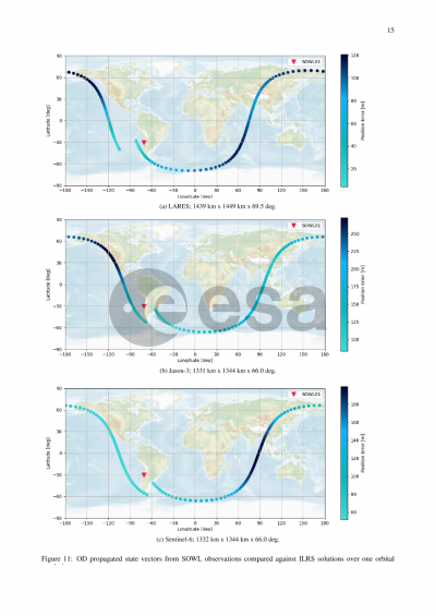
The paper then provides an overview of the architecture, design choices and implementation of the prototype. The discussion covers the data flow of tracks entering the system and also describes Neuraspace’s approach to managing multiple sources of data for both sensors and estimated ephemeris. It gives results obtained during testing and validation of the system. The analysis was performed using a combination of precise orbital data from Sentinel missions and high accuracy predictions from ILRS which were used as ground truth. Both of these data sources are publicly available.
Finally next developments are discussed including continuous assessment of prediction accuracy and covariance realism, and integration into Neuraspace’s existing Space Traffic Management platform to provide responsive orbit determination for safe and efficient spacecraft operations.
Preview