Document details
9
1
S. Lemmens, T. Flohrer, F. Schmitz

Abstract
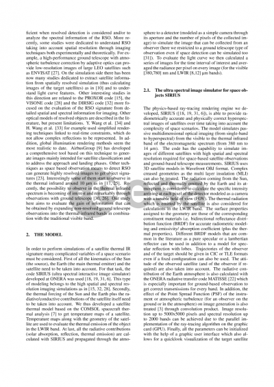
The fast increase of abandoned objects in space is becoming a dangerous threat preventing to launch new missions or to guarantee operational standards. Hence, it is crucial to follow and track space debris. Optical techniques offer cheap alternative relatively to their radar counterpart. Especially, when low resolution imaging is exploited to get fast object tracking from telescopes. Nevertheless, optical tracking in the visible spectrum suffers the limitation related to the Sun illumination conditions in order to get enough light to detect the object. We therefore study the possibilities offered by thermal infrared optical detection in the MWIR and LWIR bands in order to be able to ensure the tracking in the absence of direct solar light. Hence, we developed a 3D thermal model for space objects. This model is based on COMSOL (https://www.comsol.com/) and exports temperature maps to feed the emitted radiance calculation for all the parts lying on the space-pointing external surface of a satellite. We used the SIRIUS code [1] for the evaluation of the optical signature of the space objects in the thermal bands (taking into account the Sun and Earth radiative contributions and the emitted thermal flux of the satellite). This tool based on GPU implementation generates hyperspectral images highly spectrally and spatially resolved. In particular we focus on a theoretical study of the tracking of ENVISAT as maybe the most known European debris. We then evaluate light curves in the visible and in the MWIR-LWIR bands in order to study the gain of information carried by infrared telescope observations. Until now, very few studies have been performed in the IR range focusing especially on near earth objects [2] but these relevant results lead to believe that it is an interesting way of investigations also for debris and satellites [3]. We will in particular study the part of the scenario where ENVISAT lies in the shadow of the Earth and consider the effects of the Earth emission on the MWIR-LWIR light curves. The reflectivity of ENVISAT is modeled by the Spectral Bidirectional Reflectance Distribution Function (sBRDF) for each material with physical modelling of geometry wrinkling for MLI. Emissivity spectra are also taken into account for the different materials. The radiative environment is composed by the Sun and the Earth. Finally, the orbit is calculated through the use of TLE files.
To summarize, the paper will study theoretically the gain of information related to a spatially non-resolved optical detection of a satellite from a ground telescope in the thermal infrared bands in order to understand the type of information that can be obtained in the IR bands and to track the satellite when it lies in the shadow of the Earth. The key quantity that will be considered is the IR light curve and its dependence on the Earth emissivity map and atmosphere, the thermal/optical materials on ENVISAT, the transient between the solar lighting and shadow phases and the (possible) thermal effect of electronics onboard the satellite.
1) COIRO, Eric, TRICOLI, Ugo, MARGALL, François, et al. Hyperspectral optical modeling of resident space objects at high spatial resolution. In : Algorithms, Technologies, and Applications for Multispectral and Hyperspectral Imaging XXX. SPIE, 2024. p. 70-78.
2) HORA, Joseph L., SIRAJ, Amir, MOMMERT, Michael, et al. Infrared light curves of near-Earth objects. The Astrophysical Journal Supplement Series, 2018, vol. 238, no 2, p. 22.
3) VELEZ-REYES, Miguel, ERIVES, Hector, NAJERA, Aryzbe, et al. Understanding non-resolved space object signatures for space domain awareness. In : Advanced Maui Optical and Space Surveillance Technologies (AMOS) Conference. 2022.
Preview